Collections » Public Domain Images » Earth As Art Collection 2 »
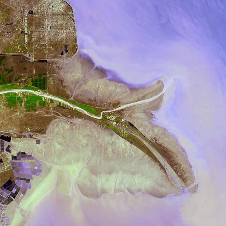
Yellow River Delta, China

Buy a Fine Art Print
The Yellow River is the second-longest river in China, and the sixth longest in the world. It drains a basin area of 740,000 square kilometers. It has been the cradle of Chinese civilization; but frequent devastating floods have also earned it the name of China's Sorrow. Historical maps from ~200BCE indicate the Yellow River was then flowing considerably north of its present course. A major course change in 1194 took over the Huai River drainage system throughout the next 700 years. The Yellow River adopted its present course in 1897 after the latest course change occurred in 1855. Currently, the Yellow River ends in the Bohai Sea, yet its eastern terminus continues to oscillate from points north and south of the Shandong Peninsula in its many dramatic shifts over time. The two ASTER images, acquired in 2001 (left) and 2009 (right), dramatically show the changes. The images cover an area of 36.5 x 41.4 km, and are located near 37.6 degrees north latitude, 119 degrees east longitude. Caption information from Wikipedia.


I take great pride in my images, so I want to make sure my customers are getting the highest quality products possible. My high resolution images are printed by some of the largest and most respected print fulfillment companies in the world, using professional grade printers on museum quality archival (acid-free) papers and canvases. Metal prints are printed on high gloss aluminum sheets, and are durable, light weight, and waterproof. Unframed prints ship in durable cardboard tubes, while framed and metal prints ship in flat boxes. Your professionally assembled custom fine art is usually ready to ship in 5-7 business days.
Just because you don't see it here, doesn't mean you can't have it the way you want it! I'm constantly adding new print options, frames, and mats. If you're looking for a particular frame or print material, custom size or crop, or even advice on what kind of print would look good in your space, just contact me, and I'll do my best to help you meet your needs.

Framed prints are professionally mounted and assembled by expert framing staff and arrive "ready-to-hang" with pre-attached hanging wire, mounting hooks, and nails. High-grade acrylic is used for glazing, which won't break in shipping. Frames are available to us at wholesale prices, which are typically 25-40% less than retail framing shops. If you're planning on framing a fine art print anyway, why not get it done professionally for less?

Add style and personality to any room with this fine art canvas print. Images are printed on premium canvas and mounted on 1.5" wooden stretcher bars. Wrap options include solid color (white or black), natural wrap, or mirrored wrap. Rolled canvas is an alternate option, and includes a 2.5" white border to allow for future mounting. Shipped to your door ready to hang, with pre-attached hanging wire or sawtooth hanger.

Hang a modern work of art on your wall, with these stylish metal prints. A high gloss finish adds depth and boldness to colors printed on a 1/16" thick sheet of aluminum. A hanging plate is attached to the back, to float the print 1/2"-3/4" from the wall, and rubber bumpers on all four corners stabilize the print when hung. These amazing lightweight prints are durable and even water proof!
Questions? Comments? Need stock or a photo shoot? Contact me!


