Collections » Around Chicago » Chicago Aerial Photography »
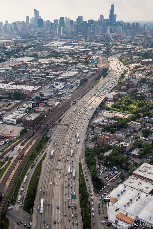
Kennedy Expressway and Chicago Skyline

Buy a Fine Art Print
The John F. Kennedy Expressway is a 17.8-mile-long freeway in metropolitan Chicago, Illinois, in the United States that travels northwest from the neighborhood of West Loop to O'Hare International Airport. The highway is named for the 35th U.S. President, John F. Kennedy, and conforms to the Chicago-area convention of using the term Expressway for an Interstate Highway without tolls. The Interstate 90 (I-90) portion of the Kennedy is a part of the much longer I-90 (which runs 3,111.52 miles from Boston, Massachusetts to Seattle, Washington). The Kennedy's official endpoints are the Circle Interchange with Interstate 290 (Eisenhower Expressway/Congress Parkway) and the Dan Ryan Expressway (also I-90/94) at the east end, and the O'Hare Airport terminals at the west end. The Interstate 190 portion of the Kennedy is 3.07 miles long and is meant to serve airport traffic. Interstate 90 picks up the Kennedy designation and runs a further 6.29 miles, before joining with I-94 for the final 8.44 miles.


I take great pride in my images, so I want to make sure my customers are getting the highest quality products possible. My high resolution images are printed by some of the largest and most respected print fulfillment companies in the world, using professional grade printers on museum quality archival (acid-free) papers and canvases. Metal prints are printed on high gloss aluminum sheets, and are durable, light weight, and waterproof. Unframed prints ship in durable cardboard tubes, while framed and metal prints ship in flat boxes. Your professionally assembled custom fine art is usually ready to ship in 5-7 business days.
Just because you don't see it here, doesn't mean you can't have it the way you want it! I'm constantly adding new print options, frames, and mats. If you're looking for a particular frame or print material, custom size or crop, or even advice on what kind of print would look good in your space, just contact me, and I'll do my best to help you meet your needs.

Framed prints are professionally mounted and assembled by expert framing staff and arrive "ready-to-hang" with pre-attached hanging wire, mounting hooks, and nails. High-grade acrylic is used for glazing, which won't break in shipping. Frames are available to us at wholesale prices, which are typically 25-40% less than retail framing shops. If you're planning on framing a fine art print anyway, why not get it done professionally for less?

Add style and personality to any room with this fine art canvas print. Images are printed on premium canvas and mounted on 1.5" wooden stretcher bars. Wrap options include solid color (white or black), natural wrap, or mirrored wrap. Rolled canvas is an alternate option, and includes a 2.5" white border to allow for future mounting. Shipped to your door ready to hang, with pre-attached hanging wire or sawtooth hanger.

Hang a modern work of art on your wall, with these stylish metal prints. A high gloss finish adds depth and boldness to colors printed on a 1/16" thick sheet of aluminum. A hanging plate is attached to the back, to float the print 1/2"-3/4" from the wall, and rubber bumpers on all four corners stabilize the print when hung. These amazing lightweight prints are durable and even water proof!
Questions? Comments? Need stock or a photo shoot? Contact me!


