Collections » Public Domain Images » Earth As Art Collection 1 »
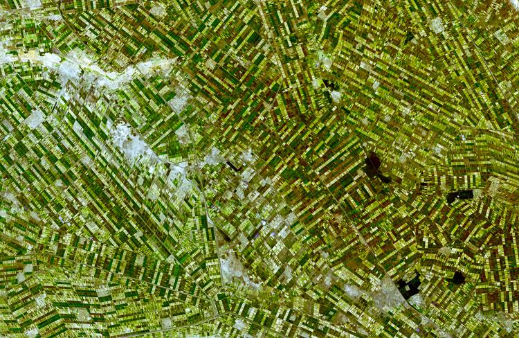
Al Jazirah, Sudan

Buy a Fine Art Print
Al Jazirah (also Gezira) is one of the 26 states of Sudan. The state lies between the Blue Nile and the White Nile in the east-central region of the country. It is a well populated area suitable for agriculture. The area was at the southern end of Nubia and little is known about its ancient history and only limited archaeological work has been conducted in this area. The region has benefited from the Gezira Scheme, a program to foster cotton farming begun in 1925. At that time the Sennar Dam and numerous irrigation canals were built. Al Jazirah became the Sudan's major agricultural region with more than 2.5 million acres (10,000 km) under cultivation. The initial development project was semi-private, but the government nationalized it in 1950. Cotton production increased in the 1970s but by the 1990s increased wheat production has supplanted a third of the land formerly seeded with cotton.


I take great pride in my images, so I want to make sure my customers are getting the highest quality products possible. My high resolution images are printed by some of the largest and most respected print fulfillment companies in the world, using professional grade printers on museum quality archival (acid-free) papers and canvases. Metal prints are printed on high gloss aluminum sheets, and are durable, light weight, and waterproof. Unframed prints ship in durable cardboard tubes, while framed and metal prints ship in flat boxes. Your professionally assembled custom fine art is usually ready to ship in 5-7 business days.
Just because you don't see it here, doesn't mean you can't have it the way you want it! I'm constantly adding new print options, frames, and mats. If you're looking for a particular frame or print material, custom size or crop, or even advice on what kind of print would look good in your space, just contact me, and I'll do my best to help you meet your needs.

Framed prints are professionally mounted and assembled by expert framing staff and arrive "ready-to-hang" with pre-attached hanging wire, mounting hooks, and nails. High-grade acrylic is used for glazing, which won't break in shipping. Frames are available to us at wholesale prices, which are typically 25-40% less than retail framing shops. If you're planning on framing a fine art print anyway, why not get it done professionally for less?

Add style and personality to any room with this fine art canvas print. Images are printed on premium canvas and mounted on 1.5" wooden stretcher bars. Wrap options include solid color (white or black), natural wrap, or mirrored wrap. Rolled canvas is an alternate option, and includes a 2.5" white border to allow for future mounting. Shipped to your door ready to hang, with pre-attached hanging wire or sawtooth hanger.

Hang a modern work of art on your wall, with these stylish metal prints. A high gloss finish adds depth and boldness to colors printed on a 1/16" thick sheet of aluminum. A hanging plate is attached to the back, to float the print 1/2"-3/4" from the wall, and rubber bumpers on all four corners stabilize the print when hung. These amazing lightweight prints are durable and even water proof!
Questions? Comments? Need stock or a photo shoot? Contact me!


